
The Radnor Historical Society houses a large collection of historic maps and atlases of our area. The maps were made for various purposes in the late 19th and early 20th centuries, usually for real estate uses. Atlases were made to document properties along the Pennsylvania Railroad, and were beautifully printed and hand-colored.
Our thanks to the Athenaeum of Philadelphia’s Greater Philadelphia GeoHistory Network for digitization and hosting. Copies of each map and atlas page are available to purchase via links on each map page.
(View the collection on philageohistory.org)
On This Page:
Atlases Including Radnor Township
Other Atlases in our Collection
Maps
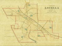 Plan of Louella
The Property of J. Henry Askin, Radnor, Delaware County
ca. 1870
Collection of the Radnor Historical Society
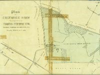 Plan of Edgewood Farm
The Property of Francis Fenimore Esq., Radnor Township, Delaware Co., Pa.
ca. 1875
Collection of the Radnor Historical Society
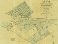
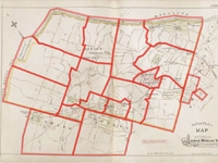
 Wayne (South of Lancaster Avenue)
ca. 1880
Geo. W. Hancock, Eng.
Collection of the Radnor Historical Society
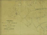
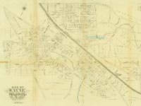
 Wayne
Wayne
ca. 1882
Engraved by Wm. Bracher, Printed by F. Bourquin
Collection of the Radnor Historical Society
 Wayne
Wayne
ca. 1886
F. Bourquin, Lith.
Collection of the Radnor Historical Society
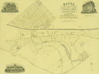
 Map of Wayne, Delaware County, Pa.
ca. 1892
E.W. Smith & Co.
Collection of the Radnor Historical Society
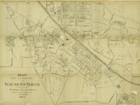
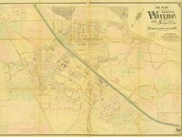 Map Showing Wayne and Surroundings
1893
A. H. Mueller
Collection of the Radnor Historical Society
View Map
View Second Copy of This Map
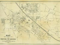 Map Made for Directory of Wayne & St. Davids
1897
A. H. Mueller
Collection of the Radnor Historical Society
 Map Made for Directory of Wayne & St. Davids
1904
Wayne Title and Trust Co.
Collection of the Radnor Historical Society
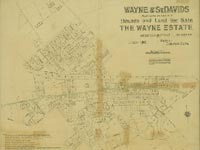 Wayne & St. Davids, Houses and Land for Sale, The Wayne Estate
1905
W.C. Hunter, Lith.
Collection of the Radnor Historical Society
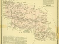
 Ardrossan
1917-1922
Platt, Yungman & Co. Insurance, Philadelphia
Collection of the Radnor Historical Society
Atlases Including Radnor Township
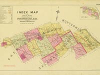
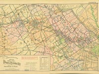
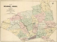 Atlas of Delaware County, Pennsylvania
1870
G. M. Hopkins
Collection of the Radnor Historical Society
Start Viewing at Title Page
Start Viewing at Map Index
View Map of Radnor Township
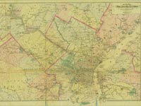
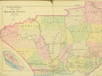
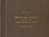 Atlas of Delaware County, Pennsylvania
1880
Benjamin H. Smith
Collection of the Radnor Historical Society
Start Viewing at List of Maps
View Map of Radnor Township, Showing the Early Grants and Patents
 Atlas of Bryn Mawr and Vicinity
1881
G. M. Hopkins
Collection of the Radnor Historical Society
Start Viewing at Title Page
Start Viewing at Map Index
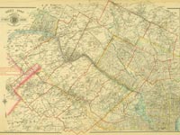
 Atlas of Properties Along the Pennsylvania R.R. from Overbrook to Malvern Station
1887
G. Wm. Baist, Published by J. L. Smith
Collection of the Radnor Historical Society
Start Viewing at Title Page
Start Viewing at Map Index
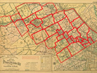
 Farm Line and Borough Atlas of Delaware County, Pennsylvania
1892
Wm. S. Miller, St. J. Ogier, Wm. S. McDonald & Forsey Breou; Published by E.W. Smith and A.H. Mueller
Collection of the Radnor Historical Society
 Baist’s Atlas of the Properties in the Northwest Suburbs of Philadelphia
1893
G. Wm. Baist
Collection of the Radnor Historical Society
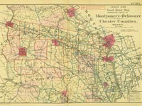
 Atlas of Lower Merion, Montgomery Co., including part of Delaware Co. and Overbrook Farms, Wynnefield, and Overbrook Impr. Co., Philadelphia
1896
A.H. Mueller
Collection of Lower Merion Township
Start Viewing at Title Page
Start Viewing at Map Index
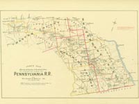
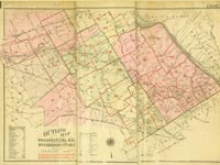
 Atlas of Properties on Line of Pennsylvania R.R. from Rosemont to West Chester
1897
Ellis Kiser, Otto Barthel & St. Julian Ogier, Published by A.H. Mueller
Collection of the Radnor Historical Society
Start Viewing at Title Page
Start Viewing at Map Index
 Atlas of Properties Along the Pennsylvania R.R. from Overbrook to Malvern Station
1900
E. V. Smith, Topographical Engineer, Published by J.L. Smith
Collection of the Radnor Historical Society
Start Viewing at Title Page
Start Viewing at Map Index
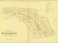
 Atlas of Properties on Main Line Pennsylvania Railroad from Overbrook to Paoli
1908
Ellis Kiser, C.E., Published by A.H. Mueller
Collection of the Radnor Historical Society
Start Viewing at Title Page
Start Viewing at Map Index
 Atlas of Properties on Main Line Pennsylvania Railroad from Overbrook to Paoli
1913
A. H. Mueller, Publisher
Collection of the Athenaeum of Philadelphia
Start Viewing at Title Page
Start Viewing at Map Index
Atlas of the Properties on Main Line Pennsylvania Railroad from Overbook to Paoli
1920
A. H. Mueller, Publisher
Collection of the Athenaeum of Philadelphia
Start Viewing at Title Page
Start Viewing at Map Index
 Atlas of the Properties on Main Line Pennsylvania Railroad from Overbook to Paoli
1926
George W. and Walter S. Bromley
Collection of the Radnor Historical Society
Start Viewing at Title Page
Start Viewing at Map Index
Later Main Line Atlases
Hosted by the Township of Lower Merion
1937 – Property Atlas Of The Main Line (Franklin Survey Co.)
1948 – Property Atlas Of The Main Line (Franklin Survey Co.)
1961 – Property Atlas Of The Main Line (Franklin Survey Co.)
Other Atlases in Our Collection
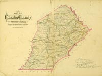
 Atlas of Chester County, Pennsylvania
1873
H.F. Bridgens, A.R. Witmer
Collection of the Radnor Historical Society
Start Viewing at Title Page
Start Viewing at Map Index
 Chester County, Pennsylvania: Breou’s Official Series of Farm Maps
1883
W.H. Kirk & Co.
Collection of the Radnor Historical Society
Start Viewing at Title Page
Start Viewing at Map Index
 Atlas of Properties on Main Line Pennsylvania Railroad from Devon to Downingtown and West Chester
1912
J. M. Lathrop and St. Julian Ogier, Civil Engineers, Published by A.H. Mueller
Collection of the Radnor Historical Society
Start Viewing at Title Page
Start Viewing at Map Index
Other Local Atlas Resources
The following external websites contain Main Line atlases from many years ranging from the mid-19th Century up through the 20th Century. Each atlas covers a large geographic area, the “Main Line” atlases usually containing Overbrook to Malvern. Pages showing parts of Radnor Township are within many of these.
The following websites are not affiliated with the Radnor Historical Society and are listed here for reference only.
Penn State University Libraries – Sanborn Fire Insurance Maps
Color scans of specific areas, with precise building outlines but no property owners specified.
Wayne-St. Davids – June 1902
Wayne-St. Davids – May 1909
Wayne-St. Davids – March 1914
Lower Merion Township/Library System – Historical Atlases
Full black and white scans of many atlases.
Lower Merion Historical Society – Main Line Atlases Collection
Nicely laid out collection of atlases, many in color, with an easy to use grid viewing system.
Andy’s Antique Atlases
Color scans of many atlases; reproductions of pages out of these atlases are available for sale through this website. Operated by Franklin Maps of King of Prussia.