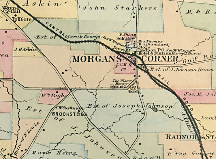
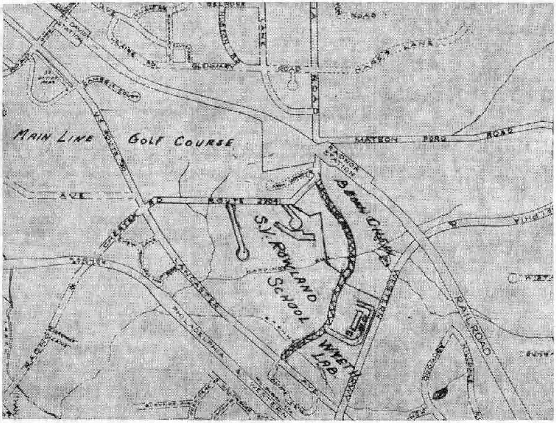
 The first map shown in today’s column is part of a rare old real estate map of Radnor township made in 1873. The second map, which is a small part of the most recent Radnor township map, shows almost the same section as it looks 81 years later. The comparison makes an interesting one, especially in view of the location of the new Sydney V. Rowland School, the Wyeth Laboratories and the Main Line Golf Club, which is the site of the proposed new shopping center for this section of the Main Line.
The center of interest in the first map is Morgan’s Corner Station, the importance of which is emphasized by the fact that the size of the lettering on the map far exceeds that of any other point in the whole township.
Radnor Station of 1873 was considerably to the east of Morgan’s Corner, as is clearly shown on the map. According to old railroad records it was only a year after this map was made that Morgan’s Corner became Radnor, and the small station called Radnor on the map was renamed Upton. About a year after this the Upton Station was torn down.
The present Matsonford road, which joins the old King of Prussia road at right angles, just to the north of Radnor Station, was called Gulf road on the 1873 map. King of Prussia road takes the same course now as then, passing the Old Store, then the railroad, and after that making a rather sharp turn to the right before taking a straight course to Lancaster Pike. The first map shows that several of the houses that still stand on the right side of King of Prussia road at the turn were there in 1873, as they had probably been for many years before. This well-known turn in the road is marked by these houses on the right and by the high wall of the Chew estate on the left.
The Joseph Johnson estate formerly owned the large acreage later acquired by the Benjamin Chew family. This acreage extended from the Pennsylvania Railroad tracks to Lancaster avenue, and then from Lancaster avenue south almost to Conestoga road. A large plot, bounded by Lancaster avenue on the south, and by King of Prussia road on the west, has in recent years, been sold to the Radnor Township School District. The site of the new Rowland School, with its school field and the wooded section directly on the Pike is indicated on the second map. Between the Philadelphia and Western tracks and the school is the site of the Wyeth Laboratories, on which construction has recently been started.
Between the school and the laboratories a shaded double line on the new map indicates the course of a road, now under construction, running from Lancaster avenue in a westerly direction to King of Prussia road, at a point near Radnor Station. Interestingly enough the old map shows a road which was later abandoned running along almost the same course. (Ed. note: Known as the Radnor-Villanova road, this thoroughfare ran directly in front of the old Chew mansion, now abandoned.)
 The ownership, in 1873, of the plot of ground now occupied by the Main Line Golf Club, is not quite clear on the old map. Part of it seems to have belonged to the estate of Sarah George, with a small portion in the possession of the Pennsylvania Railroad. The holdings at that time of Henry Askin, builder of the Louella House, were so great that his property adjoined the George holdings to the west.
(To be Continued)
(Mrs. Patterson is indebted to Paul Thomas, of Radnor House, for the use of the old map, and to the Radnor Township Engineering Department for the new map, especially marked by the department for use in today’s column.)